
Open User Map
Open User Map lets you build a collaborative, customizable map that grows with your community through simple frontend submissions and approvals.
Visit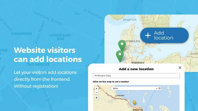
About Open User Map
Open User Map is a powerful interactive maps plugin for WordPress that transforms how you build community-driven, location-based experiences. This tool enables you to create a map that your website visitors can actively contribute to, with frontend submissions, approval workflows, and extensive customization options. The core value proposition is simplicity: you can deploy a fully functional user-contributed map without writing any code, without needing a Google Maps API key, and without complex setup procedures. Open User Map serves a wide range of users including local business directories, tourism websites, real estate platforms, event organizers, community groups, and any organization that needs to collect and display location-based information from their audience. With over 15,000 active installs, a 100% five-star rating, and ranking as the number two map plugin on WordPress.org, this tool has proven its reliability and effectiveness. The plugin empowers you to scale your data collection efforts by letting your community add locations, update existing entries, and interact through upvotes, likes, and star ratings. You maintain full control through approval workflows, ensuring all content meets your quality standards before going public. Open User Map is built for growth, allowing your map to expand organically as your community contributes more locations, categories, and information over time.
Features of Open User Map
Frontend Location Submissions and Editing
Enable your website visitors to add and edit locations directly on your map with a seamless frontend experience. When a user clicks the Add Location button, they can place a marker on the map and submit detailed information through customizable fields. All submissions enter an approval workflow where you review and approve content before it goes live. The editing capability allows users to update their existing locations, ensuring your map always reflects the most current information without requiring manual intervention from your team. This feature scales your data collection efforts exponentially as your community grows.
Advanced Marker Categorization and Filtering
Organize your map with precision by grouping locations into marker categories, each distinguished by unique icons and colors. This categorization system clarifies your map layout and enables visitors to filter through different location types instantly. Each location can belong to multiple categories, ensuring all relevant attributes are represented and easily accessible. The filtering interface creates a dynamic experience where users can narrow down results based on their specific interests, whether they are looking for restaurants, parks, events, or any other category you define.
Lines and Areas for Routes and Regions
Go beyond simple location markers by adding routes, paths, zones, and regions directly to your map. This feature lets you highlight trails, service areas, event grounds, neighborhoods, construction zones, or any custom shape that helps visitors understand your map at a glance. Distances and area sizes are calculated automatically, so routes and polygons include helpful measurements right out of the box. This capability is essential for tourism boards planning hiking trails, event organizers mapping festival grounds, or real estate developers showcasing property boundaries.
Custom Image as Interactive Map
Upload any image and transform it into a fully interactive map, whether it is an overlay, floor plan, event layout, game map, product diagram, campus guide, or seating chart. Users can place markers directly on top of the image with the same powerful functionality as a traditional map. You can add locations, display custom fields, enable filtering, and create an engaging clickable experience tailored exactly to your use case. This feature opens up unlimited possibilities for creative map applications beyond geographic boundaries.
Use Cases of Open User Map
Community-Driven Local Business Directory
Build a comprehensive local business directory where residents and visitors can add their favorite shops, restaurants, and services. Users submit business names, addresses, contact information, and categories directly from the frontend. The approval workflow ensures only verified businesses appear on the map. With star ratings, upvotes, and opening hours display, your directory becomes the go-to resource for the local community. The map grows organically as more people contribute, creating a valuable asset that attracts traffic and establishes your site as an authority on local businesses.
Tourism and Travel Guide Maps
Create an interactive travel guide where tourists and locals can share hidden gems, points of interest, hiking trails, and cultural landmarks. Use the Lines and Areas feature to map walking routes, scenic drives, or neighborhood boundaries. Custom fields allow contributors to add photos, descriptions, and tips. The filtering system lets visitors sort by activity type, difficulty level, or region. This community-powered approach keeps your travel content fresh and authentic, as real experiences are shared by actual visitors rather than curated by a single editor.
Real Estate Property Showcase
Develop a property listing map where real estate agents and homeowners can add available properties directly. Each listing can include custom fields for price, square footage, number of bedrooms, and property type. The categorization system separates residential, commercial, and rental properties with distinct icons. Potential buyers can filter by price range or property type to find exactly what they need. The approval workflow ensures only legitimate listings appear, maintaining trust and quality. This approach scales your property database rapidly as more agents contribute.
Event and Festival Mapping
Map out event venues, festival grounds, conference spaces, and community gatherings with precision. Use the Custom Image as Map feature to upload floor plans or site layouts and allow attendees to place markers for specific booths, stages, or amenities. The Lines and Areas feature helps define parking zones, entry points, and restricted areas. Attendees can add their own meetup points or highlight favorite spots. This interactive experience enhances event engagement and provides valuable data for organizers to improve future events based on attendee contributions.
Frequently Asked Questions
Do I need a Google Maps API key to use Open User Map?
No, you do not need a Google Maps API key to use Open User Map. The plugin is designed to work without any external API keys or complex setup procedures. This eliminates the common headache of API key management, billing concerns, and usage limits that come with Google Maps integration. You can have your interactive map up and running in minutes without any technical configuration.
How does the approval workflow work for user submissions?
When a website visitor submits a new location or edits an existing one, the content enters a pending approval state. You receive a notification and can review the submission from your WordPress admin dashboard. You have the option to approve, reject, or edit the submission before it goes live on the map. This workflow ensures that all content meets your quality standards and prevents spam or inappropriate submissions from appearing publicly.
Can I customize the fields that users fill out when adding a location?
Yes, Open User Map offers flexible custom fields that you can tailor to your specific needs. You can add text boxes, links, checkboxes, dropdowns, and more to collect exactly the information you require from map interactions. This feature allows you to gather comprehensive data such as business hours, contact details, descriptions, photos, and any other information relevant to your map use case.
Is there a free version available, and what does the PRO version offer?
Yes, there is a free version of Open User Map available for download on WordPress.org. The free version includes core functionality for creating user-contributed maps. The PRO version unlocks additional features including advanced filtering interfaces, custom image maps, lines and areas, upvotes and likes, star ratings, opening hours display, and regions functionality. You can try the PRO version free for 7 days with no credit card required, and the trial does not automatically convert to a paid subscription.
Similar to Open User Map

Built2WinWeb AI SEO
Custom PHP websites, AI Indexing Pack ($599 one‑time), and WebAgentScan SaaS ($9/mo). MCP, A2A, llms.txt, full ownership.
Unifyca
Unifyca gives agencies total control over client WordPress sites by unifying documentation, audits, maintenance, and backups in one platform.
Shadcn Examples
Ship production-ready UI faster with premium Shadcn components built for scalable React and Tailwind apps.

EdgeIQ Labs
EdgeIQ Labs gives small businesses a full security platform to find risks, automate monitoring, and scale protection without a security team.
Webleadr
Webleadr empowers you to effortlessly find and contact web design leads and businesses without websites, turning prospects into clients in clicks.
SiteMd
SiteMd is your all-in-one website health scanner that identifies issues, impacts, and fixes in under 60 seconds, ensuring optimal performance and.

Idearium
Idearium is a Toronto agency that crafts impactful websites and drives digital growth for businesses ready to scale.

FilexHost
Effortlessly host and share files in seconds with drag-and-drop simplicity and secure, shareable links.