GeoRank
GeoRank replaces weeks of relocation research with live data layers and an AI that compares your shortlisted places instantly.
VisitPublished on:
July 14, 2026
Pricing:
About GeoRank
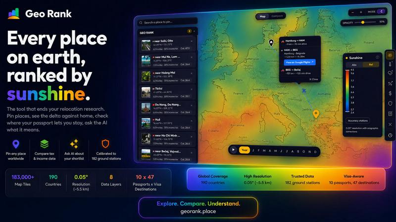
GeoRank is a free, no-signup interactive map designed to replace the fragmented research process of deciding where to relocate or spend an extended stay abroad. Instead of juggling a dozen open tabs across weather sites, cost-of-living databases, embassy pages, and nomad forums that never communicate with each other, GeoRank layers eight core data sets over a global grid with approximately five-kilometer resolution. This tool integrates calibrated sunshine and temperature data from 182 ground stations using SARAH-3, ERA5, and CHELSA sources, tax rates from OECD, PwC, and KPMG, per-passport visa and residency routes across 47 destinations for 10 different passports, cost-of-living data from 478 cities, geopolitical risk assessments, and community-sourced Nomad Pulse sentiment. Users can pin candidate locations, switch to Compare mode to see every metric as a delta against their current home, and leverage an AI assistant that reasons only over their own shortlist. Built for the actual decision of where to live next, GeoRank scales from casual exploration to rigorous comparison, making it an essential tool for digital nomads, remote workers, expats, and anyone considering a major geographic move.
Features of GeoRank
Interactive Global Map with 9 Data Layers
GeoRank provides an interactive map with nine toggleable live data layers covering sunshine, temperature, rainfall, outdoor hours, taxes, visas and residency, cost of living, geopolitical risk, and Nomad Pulse sentiment. Each layer is a live data source that users can stack and toggle independently, enabling deep dives into specific metrics. The map covers over 190 countries with 183,000 plus map tiles at 0.05 degree resolution, approximately five and a half kilometers. Users can pan globally, zoom to individual cells, and instantly visualize complex geospatial data that would otherwise require multiple disconnected research tools.
Pin and Compare Mode with Home Baseline
Users can pin any location on the map, saving up to 20 places across sessions without requiring an account or signup. The Compare mode transforms these pins into a decision matrix by allowing users to set their current home as a baseline. Every metric for each pinned location is then displayed as a delta relative to home, showing how much warmer, cheaper, safer, or differently taxed each candidate place is compared to the user's current reality. This relative comparison eliminates the cognitive load of interpreting absolute numbers and directly answers the question, "How does this place compare to where I live now?"
AI Assistant Grounded in Your Shortlist
GeoRank features a specialized AI assistant that operates exclusively on the user's pinned locations and their associated data, not on a generic knowledge base. Users can ask complex comparative questions like "Which of my five places has the best winter?" or "Score my shortlist by sunshine, cost, and low tax combined." The AI reasons across all pinned locations in a single response, providing cited, grounded answers sourced directly from the platform's data layers. This transforms raw metrics into actionable insights, helping users understand tradeoffs between locations without manual spreadsheet analysis.
Nomad Pulse Community Sentiment Layer
Beyond official data sources, GeoRank includes Nomad Pulse, a community-sourced sentiment layer that tracks weekly signals from the digital nomad community. This feature processes social posts and community discussions into rising, stable, or falling sentiment indicators per country and city. Users can see where enthusiasm is building before it becomes mainstream, spotting emerging hotspots and potential issues flagged by the community in real time. This layer adds a human dimension to quantitative data, capturing the lived experience of people already on the ground.
Use Cases of GeoRank
Digital Nomad Relocation Planning
A digital nomad with a UK passport evaluating potential bases in Europe and Asia can use GeoRank to compare Tbilisi, Paphos, Lisbon, and Chiang Mai across sunshine hours, cost of living, tax regimes, and visa-free stay duration. By pinning all four locations and setting their current home as a baseline, they can instantly see which place offers the most sunshine, lowest taxes, and longest visa-free period. The AI assistant can then answer specific questions like "Which location is best for winter with at least 2,800 sunshine hours and low income tax?" providing a data-driven recommendation with cited sources.
Remote Worker Family Relocation Assessment
A remote worker with a family considering a move from the United States to either Portugal or Spain can use GeoRank to evaluate geopolitical risk, cost of living for a family of four, and residency visa pathways. By pinning multiple cities in both countries and comparing them against their current home, they can see deltas in safety scores, monthly expenses, and tax implications for foreign-sourced income. The AI assistant can answer nuanced questions like "What are the tradeoffs between Lisbon and Valencia for raising a family?" considering school quality proxies, outdoor hours, and community sentiment.
Freelancer Tax Optimization Strategy
A freelancer generating income from multiple international clients can use GeoRank to identify jurisdictions with favorable tax treatment for foreign-sourced income. By layering the tax data with visa and residency requirements for their specific passport, they can pinpoint locations where they can legally reside while minimizing tax liability. The Compare mode allows them to stack multiple candidate locations against their current tax situation, and the AI assistant can evaluate tradeoffs between low tax rates, cost of living adjustments, and sunshine hours to recommend the optimal base for their specific financial situation.
Investor or Retiree Lifestyle Arbitrage
An investor or retiree looking to maximize purchasing power and quality of life can use GeoRank to identify locations where their income goes further while maintaining access to healthcare, safety, and favorable climate. By pinning candidate destinations across Southeast Asia, Latin America, and Southern Europe, they can compare cost of living deltas, geopolitical risk scores, and sunshine hours against their home base. The AI assistant can rank locations by combined metrics, answering questions like "Which of my pinned places offers the best value for money considering safety, climate, and monthly expenses?"
Frequently Asked Questions
Is GeoRank really free and do I need to sign up?
Yes, GeoRank is completely free to use and requires no signup or account creation. You can access the interactive map, toggle all nine data layers, pin up to 20 locations, use Compare mode, and ask the AI assistant questions about your shortlist without providing any personal information or creating a login. Your pinned locations are saved across browsing sessions using local storage in your browser.
How accurate is the sunshine and temperature data?
The sunshine and temperature data is calibrated against 182 ground stations worldwide, including locations from Reykjavik to Phoenix to Sydney. Raw satellite data from SARAH-3 and ERA5 is bias-corrected using these ground stations with orographic terrain corrections. Accuracy is approximately plus or minus eight percent for most locations, with high-altitude locations at plus or minus fifteen percent and coastal microclimates at plus or minus twenty percent. The data is updated monthly using climatology averages.
How does the visa and residency data work?
The visa and residency layer covers 47 destinations across 10 different passports, allowing users to see how their specific passport affects visa-free stay duration, visa-on-arrival options, and residency pathways for each pinned location. This data is sourced from official embassy pages and government databases. When you pin a location and set your home base, the platform automatically shows how long your passport allows you to stay in each candidate location, eliminating the need to check multiple embassy websites.
What exactly is Nomad Pulse and how is it calculated?
Nomad Pulse is a community-sourced sentiment layer that tracks weekly signals from the digital nomad community across social platforms and forums. The system processes posts and discussions into three categories: rising, stable, or falling sentiment per country and city. This provides a real-time indicator of where enthusiasm is building or declining within the nomadic community, capturing on-the-ground experiences and emerging trends that official statistics may not reflect for months or years.
Similar to GeoRank

screenRIG
Signage and kiosk infrastructure for AI agents. Your agent publishes images, video, streams, web pages and apps to screens via one plugin.screenRIG is

Genjutsu AI
Genjutsu AI turns your ideas into cinematic videos, product ads, social shorts, and high-quality images in minutes.

Orlyn
Privacy-first, cookieless web analytics that connects website traffic to real revenue.
GetYouTubeTranscript
Free YouTube transcripts on the web, a Chrome extension, and an API + MCP server so AI assistants can read YouTube.

kimik3
An independent, unofficial guide and playground for the Kimi K3 model with free chat trials, tutorials, and transparent pricing.
Tally Counter
Online tally counter for tracking attendance, workouts, inventory, visitors, sports scores, habits, and everyday counting tasks.